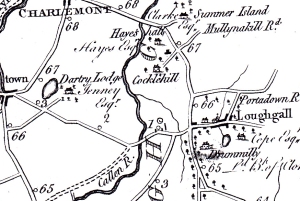
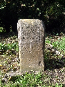
About half a mile down Cloveneden Road is an old milestone believed to be one of the milestones referred to on Taylor & Skinner maps ca 1777. It is listed as number 66, indicating that it was 66 miles to Dublin on the Dublin/Dungannon/Derry coach route. This mileage is in the old Irish measurement, which means it predates the coming into force of the Act of Union (1800) after which English miles were adopted as standard. The original markings are now almost unreadable but it would appear that as well as indicating the distance to Dublin/Armagh on one side, on the other side it may read ‘C bridge 1½ mile’ possibly a reference to an old bridge over the Callan River (now referred to as Chambers’ Bridge), essential information required for those travelling on foot, on horseback or by coach. Coach route No 53 between Dublin and Charlemont found in Leigh’s New Pocket Book of Ireland 1835 includes a reference to the Callan Bridge in this locality.


